-
Dear Guest, Please note that adult content is not permitted on this forum. We have had our Google ads disabled at times due to some posts that were found from some time ago. Please do not post adult content and if you see any already on the forum, please report the post so that we can deal with it. Adult content is allowed in the glory hole - you will have to request permission to access it. Thanks, scara
You are using an out of date browser. It may not display this or other websites correctly.
You should upgrade or use an alternative browser.
You should upgrade or use an alternative browser.
I aint no Sheikh-but lets talk weather
- Thread starter ricky2tricky4city
- Start date


WillWeEverBeGoodAgain
Johnny nice-tits
14c the week before January in the UK just isn't right is it
14c the week before January in the UK just isn't right is it
We were at a party last night. Outdoors (under a gazebo) in the middle of nowhere, so no natural shelter from other buildings etc. Coats on but otherwise really comfortable temperature wise. Totally bizarre for December.
ricky2tricky4city
Jimmy Cantrell
It's just because there is a weather system parked (stuck) to the west of Ireland in the mid Atlantic with a strong S/SW flank.
When anything gets stuck (and of a decent size) it has greater chance of 1. Affecting the jet stream and 2.Dragging warm air up from that SW direction (we know that keeps us warm anyway, given our latitude).
The downside is (especially living at the coast) it's just constant wind and showers, which is pretty boring after a while. Rather the dominant high push back in, even if it means cold air from the NE, at least there's a good chance of it then being sunny.
johnola
Dean Richards
Big change today from the mild gloomy air we have had.
3 degrees here with rain coming in from the north this morning hitting the front windows which is unusual - iPhone suggests this will turn to snow on the north downs (I am at 650ft asl) by lunchtime on the back edge of this front coming in.
Love it.
3 degrees here with rain coming in from the north this morning hitting the front windows which is unusual - iPhone suggests this will turn to snow on the north downs (I am at 650ft asl) by lunchtime on the back edge of this front coming in.
Love it.
WillWeEverBeGoodAgain
Johnny nice-tits
Storm Eunice has the potential to give 80 mph gusts inland, maybe up to 90 mph in populated places in the middle of the day on Friday. There are yellow warnings out at the moment, they could change to amber on Thursday. Of course there is always the chance that the low will develop further south and go into France but at the moment it all looks a bit daunting for the southern part of the UK.
Storm Eunice has the potential to give 80 mph gusts inland, maybe up to 90 mph in populated places in the middle of the day on Friday. There are yellow warnings out at the moment, they could change to amber on Thursday. Of course there is always the chance that the low will develop further south and go into France but at the moment it all looks a bit daunting for the southern part of the UK.
I've got the day off on Friday. Typical. Looks like I won't be venturing out very far, if at all.
Bullet
Jimmy Cantrell
Take a kite and you could go very far indeed.I've got the day off on Friday. Typical. Looks like I won't be venturing out very far, if at all.
A couple of weekends ago I went down to Christchurch and in the sea were a load of blokes on surfboards, holding 'wings' like a paraglider above their head... like a windsurf where the sail isn't attached. Bloody nutters. Looked enormously painful, tiring and chilling.
johnola
Dean Richards
what an incredible graphic that is Steve - don’t like what it is indicating.
where the f is that from and why don’t we see this sort of thing on the telly etc?
ricky2tricky4city
Jimmy Cantrell
Foiling.Take a kite and you could go very far indeed.
A couple of weekends ago I went down to Christchurch and in the sea were a load of blokes on surfboards, holding 'wings' like a paraglider above their head... like a windsurf where the sail isn't attached. Bloody nutters. Looked enormously painful, tiring and chilling.
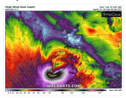
One of the latest images to come out from the models. Storm Eunice hasn't even formed yet but they are predicting explosive cyclogenesis (weather bomb event). It will not be until tomorrow lunchtime when they will be able get a better idea of the exact track. It has moved north in a few models, and gone south in a few others, so there is a range of possibilities in strength, speed and location. It is looking increasingly likely there will be 70 - 80 mph gusts through much of SE England on Friday.
Amber weather warnings now, probably turning to red. Wont know exactly where or when until a few hours before. Please listen out for the weather warnings on Thursday night.
Last edited:
No thanks.
One of the latest images to come out from the models. Storm Eunice hasn't even formed yet but they are predicting explosive cyclogenesis (weather bomb event). It will not be until tomorrow lunchtime when they will be able get a better idea of the exact track. It has moved north in a few models, and gone south in a few others, so there is a range of possibilities in strength, speed and location. It is looking increasingly likely there will be 70 - 80 mph gusts through much of SE England on Friday.
Amber weather warnings now, probably turning to red. Wont know exactly where or when until a few hours before. Please listen out for the weather warnings on Thursday night.
Could the North take its weather back now, please?
ricky2tricky4city
Jimmy Cantrell
Let's be Scottish for a day.No thanks.
Could the North take its weather back now, please?
Anyone on here down in the SW? Looks like it will be particularly bad down there.
You're using the wrong medium for that part of the world. Try carrier pigeon.
Anyone on here down in the SW? Looks like it will be particularly bad down there.